OLD TOWNS BOOKS & MAPS
Old Maps of Surrey
Essentials for Local Historians, Genealogists & Family Historians
MODERN MAPS
LOOKING FOR A DETAILED MODERN ORDNANCE SURVEY MAP OF A SURREY TOWN? CLICK HERE
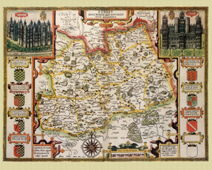
Surrey in 1610
by John Speed
Size: 16 x 20 inches
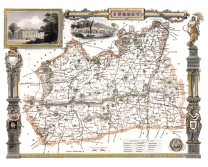
Surrey in 1830
by Thomas Moule
Size: 20 x 16 inches
Type: reproduction
PRICE: £12.49
CLICK MAP TO ENLARGE
The map is decorated with several coats-of-arms and views of Richmond Bridge and Dulwich College.
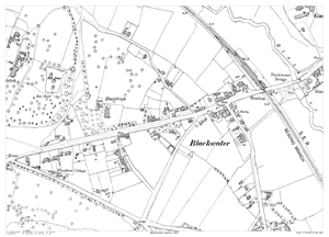
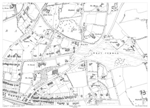
Blackwater in 1897
Size: 21.5 x 15.25 inches
Scale: 37 inches to the mile
Type: reproduction
PRICE: £7.99
CLICK MAP TO ENLARGE
Showing the area from Woodbine Cottage in the west, to the gas works in the east.
Not the most informative of maps in regard to named houses & streets,
you probably need to know the area.
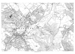
Godalming in 1919
Size: 21.5 x 15.25 inches
Scale: 6 inches to the mile
Type: reproduction
PRICE: £7.99
CLICK MAP TO ENLARGE
Showing the whole town.
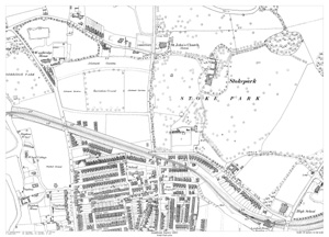
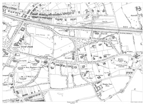
Guildford in 1895
Stoke Park area
Size: 21.5 x 15.25 inches
Scale: 37 inches to the mile
Type: reproduction
PRICE: £7.99
CLICK MAP TO ENLARGE
Showing the area from St. John's Church in the north to London Road railway station in the south, and from Dapdune Wharf in the west to Stokepark Park in the east.
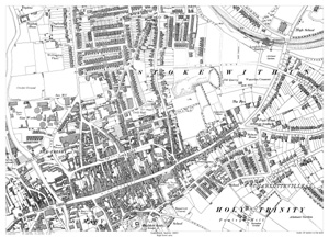
Guildford in 1895
High Street area
Size: 21.5 x 15.25 inches
Scale: 37 inches to the mile
Type: reproduction
PRICE: £7.99
CLICK MAP TO ENLARGE
Showing the area from London Road railway station in the north to the site of Guildford Castle in the south, and from Bridge Street in the west to the junction of Harvey Road and Hunter Road in the east.
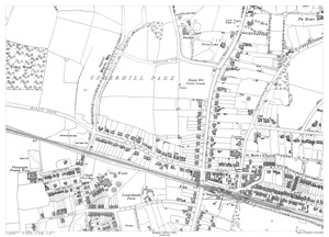
Reigate in 1895
North West
Size: 21.5 x 15.25 inches
Scale: 37 inches to the mile
Type: reproduction
PRICE: £7.99
CLICK MAP TO ENLARGE
Showing the area from Brokes Road in the north to the railway station in the south, and from Albert Road (north & south) in the west to beyond St. Mark's Church in the east.
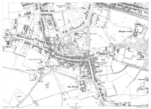
Reigate in 1895
South West
Size: 21.5 x 15.25 inches
Scale: 37 inches to the mile
Type: reproduction
PRICE: £7.99
CLICK MAP TO ENLARGE
Showing the area from the railway station in the north to The Priory in the south, and from Evesham Road in the west to Reigate Lodge in the east.
Reigate in 1895
North East
Size: 21.5 x 15.25 inches
Scale: 37 inches to the mile
Type: reproduction
PRICE: £7.99
CLICK MAP TO ENLARGE
Showing the area from The Mount in the north to Doods Road in the south, and from the junction of Wraypark Road with Alders Road in the west to Wray Common in the east.
Reigate in 1895
South East
Size: 21.5 x 15.25 inches
Scale: 37 inches to the mile
Type: reproduction
PRICE: £7.99
CLICK MAP TO ENLARGE
Showing the area from Doods Road in the north to Blackboro' Road in the south, and from Great Doods in the west to Hatchlands Corner in the east.