Old Ordnance Survey Maps of Yorkshire - Sheet 216. 9. 1893
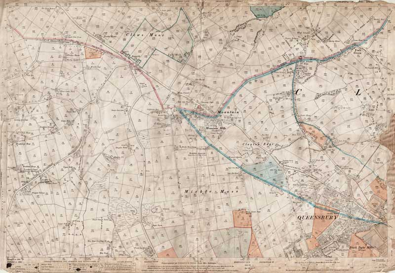
An old map of Queensbury (NW), in 1893 Scale 1:2500 or 25 inches to the mile : Original map size 40 x 29 inches [102 x 74 cms]
IMPORTANT: These unique maps originally belonged to Smith, Gotthardt & Co. of Bradford, Land Agents & Surveyors. The majority have fascinating hand-written additions referring to works and surveys carried out by the company approx. 1893 to 1920's. Despite their often poor condition, we have decided to offer them as downloadable PDF images of the original scans. They are also available as printed maps. (see below).
DESCRIPTION OF THE ORIGINAL MAP
DISTRICTS COVERED
[see modern map below]
Clews Moor, Yews Green, Mountain, Clayton Edge, Mickle Moss, Queensbury (inc. Black Dyke Mills) TO CONFIRM A LOCATION ON THIS MAP, PLEASE EMAIL US YOUR QUERY BEFORE PURCHASE.
HAND-WRITTEN ADDITIONS
Various boundaries & plots outlined or coloured-in, with no explanations.
CONDITION
some losses to borders and map edges , otherwise creased but legible.
PURCHASE THIS MAP
DOWNLOAD THE ORIGINAL MAP SEEN BELOW complete with any additions as described above
INSTANT PDF DOWNLOAD £5.99*
BUY A PRINTED MAP Posted rolled in a tube.
A1 size (33x24 inches), 120gsm coated £12.99
* PayPal insists on adding postage to these downloads, so the checkout states the price as £2.99 + £3.00 shipping
VIEW A SAMPLE MAP IN PDF FORMAT<< CLICK HERE >>you must use the Zoom function
< Return to Sheet 216 keymap > Modern equivalent area from Google Maps [NOTE- approx. area only - please email if you need to confirm a location on the old map (above) before purchase]