 |
HOME | BOOKS | PRINTED MAPS | MAPS ON CD-ROM | GENEALOGISTS | CONTACT US | PRIVACY |
||
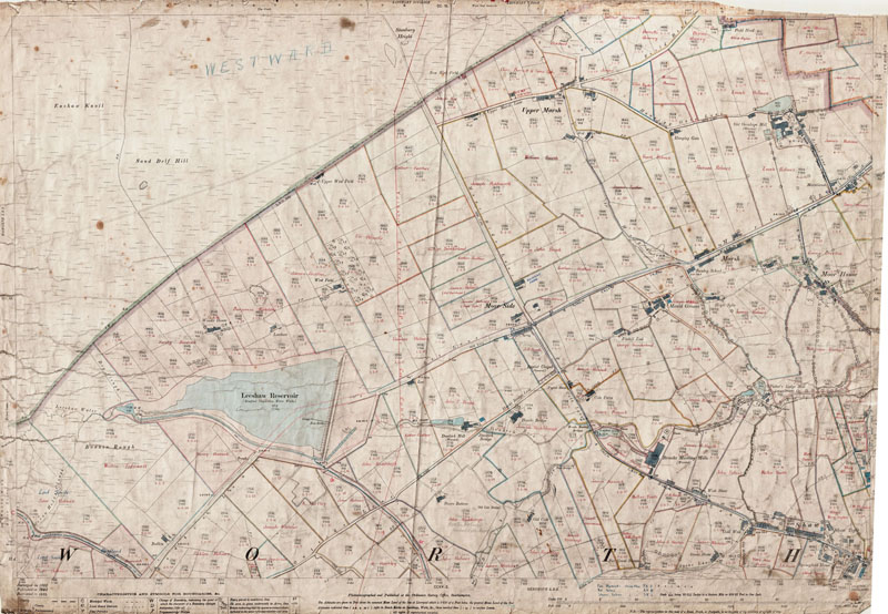
Old Ordnance Survey Maps of Yorkshire - Sheet 200. 14. 1893a
Oxenhope (NW) in 1893
Scale 1:2500 or 25 inches to the mile : Original map size 40 x 29 inches [102 x 74 cms]
Please refer to the modern map shown below.
Switching views from 'Sat' to 'Map' may be useful.
TO CONFIRM A LOCATION ON THIS MAP, PLEASE EMAIL US YOUR QUERY BEFORE PURCHASE.All fields and plots in the Oxenhope parish section of the map have names written on them in red ink, with pencil notes from a later date which are hard to read in some cases. It is not stated whether the names are of owners or tenants.
Names in red ink include:
Joseph Roe, Charles Barrett & Sons Ltd., Feather Bancroft, James Feather, Barretts Quarry, Ellis Ryder, William Brown, Binns' Quarry, Enoch Holmes, J. Dixon, James Holmes, Sam Holmes, Emma Crabtree, Pearson Holmes, Frank Holmes, Joseph Mitchell, William Smith, Joseph Holdsworth, John Brook, Esther Feather, Thomas Holmes, George Sunderland, Eli Wharfe, Susey Boocock, Benjamin Ratcliffe, John T. Brook, James H. Booth, Joseph Reddiough, Greenwood Booth, Wilkinson Witham, Lot Howker, Mary Whitaker, Mary Brown, Walker Booth, J. W. Whitaker, Albert Normington, Alfred Speak, Mary Ann Booth, James Boocock, John S. Heaton, Joseph Greenwood, John Reddiough, John Holmes, A. Hartley, Jonas Sunderland, Pickles Holmes, Willie Tidswell, Sam Holmes.
Some names have been crossed out and new ones written, some are legible, some are not.
PURCHASE
300dpi scan of the map seen below
complete with any additions as described above
£5.99

LARGE PRINTED MAP
Near full-size colour print of the map below.
33 x 24 inches on 120gsm coated paper.
Posted rolled in a tube.
£12.99
< Return to Menu >
Modern equivalent area from Google Maps
[NOTE- approx. area only - please email if you need to confirm a location on the old map (above) before purchase]
View Larger Map